通过shaplefile裁剪NetCDF
NetCDF(http://www.unidata.ucar.edu/software/netcdf/)格式是比较常见的地学数据存储格式,但是,很多NetCDF数据都是全球或大区域尺度,存储整个数据很浪费空间(比如中国区域CFMD数据集解压后占据硬盘380多G,而占国土面积1/4的青藏高原裁剪后的CFMD-QTP预计能节约90%的空间),网上找了很久也没有找到合适的裁剪code。本文描述了通过shapefile来裁剪Python的思路(需要netcdf4-python、gdal 等支持)。
1.效果
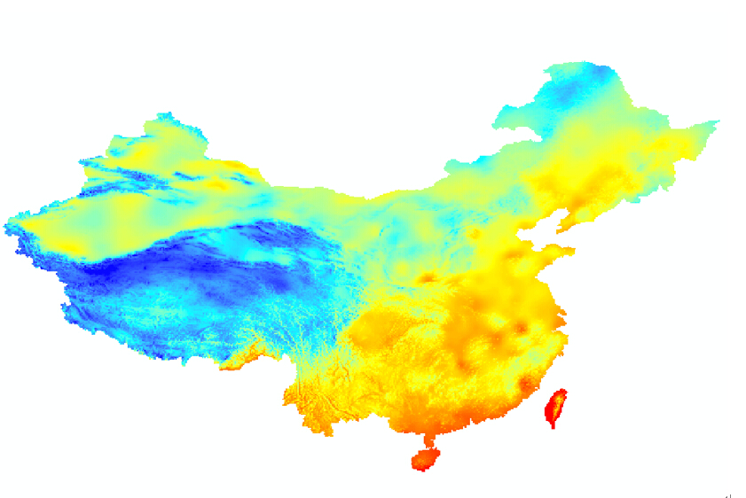
示例NetCDF下载地址http://westdc.westgis.ac.cn/data/7a35329c-c53f-4267-aa07-e0037d913a21
原始数据(130M):
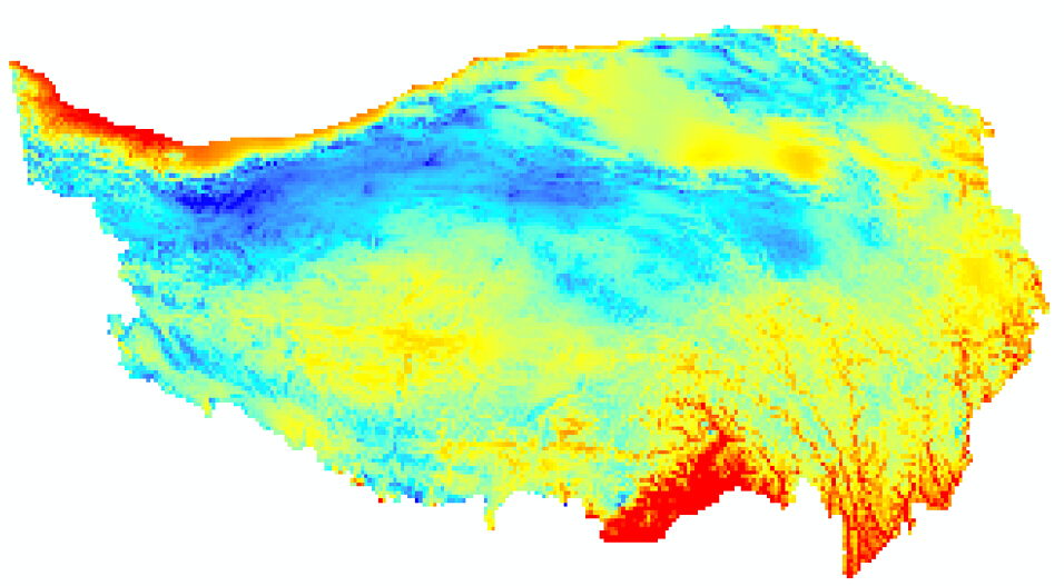
通过青藏高原边界clip后的数据(18M):
2.实现(需要PYTHON运行,数据量大时,建议python 64bit,支持批处理。)
具体思路如下:
- gdal计算shapefile 的 四角boundary 和所有点的boundary
- 其次根据四角boundary subset
- 在根据所有点boundary 计算netcdf mask并更新到QTP netcdf 的mask
- netcdf4-python将mask后netcdf的文件写出来 具体code如下:
##########################################################################################################
# NAME
#    SubSetNetCDF.py
# PURPOSE
#
# PROGRAMMER(S)
#   wuxb
# REVISION HISTORY
#    20150910 -- Initial version created and posted online
#
# REFERENCES
##########################################################################################################
import numpy as np
import numpy.ma as ma
import os
import formic
import datetime
from netCDF4 import Dataset
from osgeo import gdal, ogr
###################################################################################
# input data
###################################################################################
strShpFilePath      = "D:\\Temp\\Shp\\Tibet_Plateau_Boundar.shp"
strNetCDFPathInput  = "E:\\ForcingData\\DAT-31.12_NG_ITPCAS-CMFD_V0106_B-01\\Data_forcing_03hr_010deg_Unzip\\"
strNetCDFPathOutput = "D:\\workspace\\Data\\CFMD(QTP)\\"
###################################################################################
# Process
# read
# process
# write
###################################################################################
#read shapefile
shpDS = ogr.Open(strShpFilePath)
shpLyr = shpDS.GetLayer()
Envelop = shpLyr.GetExtent()
xmin,ymin,xmax,ymax = [Envelop[0],Envelop[2],Envelop[1],Envelop[3]] #Your extents as given above
mask_RES = []
#
fileset = formic.FileSet(include="**/*.nc", directory=strNetCDFPathInput)
nFile = 0 # print process file ID

########################################################################
#Function
#
########################################################################
def find_all_index(arr,item):
    return [i for i,a in enumerate(arr) if a==item]

def getDimVar(ncInput,varList,varName):
    varIdx  = find_all_index(varList,varName)
    if(len(varIdx) == 1):
        varData = ncInput.variables[varName][:]
        varList.remove(varName)
        return varData
    else:
        print "Error there have no dim"
        os.system("pause")
        exit(0)

def getDataVar(ncInput,varList):
    #check varlist
    if(len(varList) == 1):
        varName = str(varList[0])
        varData = ncInput.variables[varName][:]
        return varName,varData
    else:
        print "Error there have no dim"
        os.system("pause")
        exit(0)

########################################################################
#Process
########################################################################
for file_name in fileset:
    nFile+=1
    print "################################################################"
    print "Current file is : " + file_name + "; It is the " + str(nFile)
    print "################################################################"
    #read netcdf lon lat data
    ncInput     = Dataset(file_name,'r', Format='NETCDF3_CLASSIC')
    #list variables
    varList     = ncInput.variables.keys()
    #get var
    lon_Ori     =  getDimVar(ncInput,varList,'lon')
    lat_Ori     =  getDimVar(ncInput,varList,'lat')
    time        =  getDimVar(ncInput,varList,'time')
    varDataName,varData_Ori  =  getDataVar(ncInput,varList)
    ########################################################################
    #create mask
    ########################################################################
    if len(mask_RES) == 0 :
        #get boundary and xs ys
        lat_bnds, lon_bnds = [ymin, ymax], [xmin, xmax]
        lat_inds = np.where((lat_Ori > lat_bnds[0]) & (lat_Ori < lat_bnds[1]))
        lon_inds = np.where((lon_Ori > lon_bnds[0]) & (lon_Ori < lon_bnds[1]))
        ncols = len(lon_inds[0])
        nrows = len(lat_inds[0])
        #create geotransform
        xres = (xmax - xmin) / float(ncols)
        yres = (ymax - ymin) / float(nrows)
        geotransform = (xmin,xres,0,ymax,0, -yres)
        #create mask
        mask_DS = gdal.GetDriverByName('MEM').Create('', ncols, nrows, 1 ,gdal.GDT_Int32)
        mask_RB = mask_DS.GetRasterBand(1)
        mask_RB.Fill(0) #initialise raster with zeros
        mask_RB.SetNoDataValue(-32767)
        mask_DS.SetGeoTransform(geotransform)
        maskvalue = 1
        err = gdal.RasterizeLayer(mask_DS, [maskvalue], shpLyr)
        mask_DS.FlushCache()
        mask_array = mask_DS.GetRasterBand(1).ReadAsArray()
        mask_RES = ma.masked_equal(mask_array, 255)
        ma.set_fill_value(mask_RES, -32767)
    ########################################################################
    #subset
    ########################################################################
    var_subset = varData_Ori[:,min(lat_inds[0]):max(lat_inds[0]) + 1, min(lon_inds[0]):max(lon_inds[0]) + 1]
    var_subset._set_mask(np.logical_not(np.flipud(mask_RES.mask)))  # update mask (flipud is reverse 180)
    lon_subset = lon_Ori[lon_inds]
    lat_subset = lat_Ori[lat_inds]
    ###################################################################################
    # Open a new NetCDF file to write the data to.  For format, you can choose
    # from
    # 'NETCDF3_CLASSIC', 'NETCDF3_64BIT', 'NETCDF4_CLASSIC', and 'NETCDF4'
    ###################################################################################
    #create file path and name
    InputFileDir,InputFile = os.path.split(file_name)
    InputDir,InputFileDirName = os.path.split(InputFileDir)
    OutputFileDir = os.path.join(strNetCDFPathOutput,InputFileDirName)
    if not os.path.exists(OutputFileDir):
        os.makedirs(OutputFileDir)
    strInputFileList = InputFile.split('_')
    strInputFileList[1] = strInputFileList[1] + "-QTP"
    OutfileName = '_'.join(strInputFileList)
    OutputFileDirName = os.path.join(OutputFileDir,OutfileName)
    #create file
    ncOutput = Dataset(OutputFileDirName, 'w', format='NETCDF3_CLASSIC')
    ncOutput.description = "Extract Data %s from CFMD by QTP shapefile. %s" % \
                      (ncInput.variables[varDataName].long_name.lower(),ncInput.description)
    # Using our previous dimension info, we can create the new time dimension
    # Even though we know the size, we are going to set the size to unknown
    ncOutput.createDimension('time', None)
    ncOutput.createDimension('lon', ncols)
    ncOutput.createDimension('lat', nrows)

    # Add lon Variable
    var_out_lon = ncOutput.createVariable('lon', ncInput.variables['lon'].dtype,('lon',))
    for ncattr in ncInput.variables['lon'].ncattrs():
        var_out_lon.setncattr(ncattr, ncInput.variables['lon'].getncattr(ncattr))
    ncOutput.variables['lon'][:] = lon_subset

    # Add lat Variable
    var_out_lat = ncOutput.createVariable('lat', ncInput.variables['lat'].dtype,('lat',))
    for ncattr in ncInput.variables['lat'].ncattrs():
        var_out_lat.setncattr(ncattr, ncInput.variables['lat'].getncattr(ncattr))
    ncOutput.variables['lat'][:] = lat_subset

    # Add time Variable
    var_out_time = ncOutput.createVariable('time', ncInput.variables['time'].dtype,('time',))
    for ncattr in ncInput.variables['time'].ncattrs():
        var_out_time.setncattr(ncattr, ncInput.variables['time'].getncattr(ncattr))
    ncOutput.variables['time'][:] = time

    # Add data Variable
    var_out_data = ncOutput.createVariable(varDataName, ncInput.variables[varDataName].dtype, ("time","lat","lon",))
    for ncattr in ncInput.variables[varDataName].ncattrs():
        var_out_data.setncattr(ncattr, ncInput.variables[varDataName].getncattr(ncattr))
    ncOutput.variables[varDataName][:] = var_subset

    # attr
    ncOutput.history = "CLIP Created datatime" + datetime.datetime.now().strftime("%Y-%m-%d %H:%M:%S") + " by CAREERI  wuxb"
    ncOutput.source  = "netCDF4 1.1.9  python"
    ###################################################################################
    # write close
    ###################################################################################
    # close
    ncOutput.close()  # close the new file
    ncInput.close()   # close ori file

print 'Done'
print 'End time: ' + datetime.datetime.now().strftime("%Y-%m-%d %H:%M:%S")